Find Us:

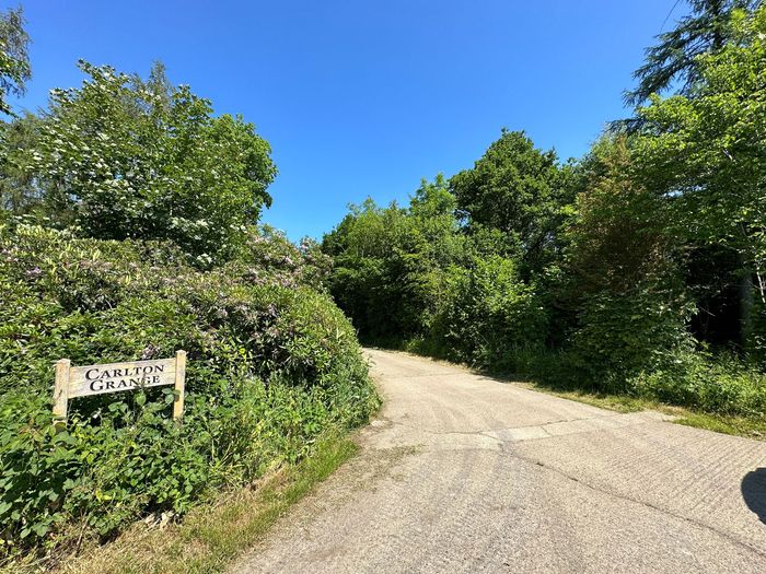
Keld Down Plantation

Carlton Grange

Eppleby

Nr Richmond,

North Yorkshire

DL11 7AF

History of Stanwick Camp


There is little doubt that the predominant tribe which inhabited the land between the river Humber and the Tweed were the Brigantes. That they were also well known in the ancient world is indisputable, having been mentioned in Greek and Roman texts.


Stanwick Camp, a Brigantian settlement, covers and area of c.700 acres and is regarded as the largest pre-Roman/ Iron Age settlement in Britain and is only outstripped in grandeur by Maiden Castle near Dorchester in Dorset. The fact that it lies on the major North-South trade route east of the Pennines and close to the East-West route across the spine of Britain is no accident. It also has it’s own water supply, Mary Wild Beck.


There is also no doubt that the site had been in use since at least the Bronze Age, as significant finds have been made from this era within the camp’s vast enclosure. By about 200 B.C. there were also a number of Iron Age houses at the site surrounded by pasture and arable land, but the real expansion of the site began during the 1st Century A.D. This expansion followed the major upheavals after the Roman Conquest post A.D. 43. It is no accident the Romans came to these shores. They were very aware of the riches the island possessed in raw materials and manufactured goods and wished to share the spoils. The invaders also preferred the path of least resistance, and so would rather subjugate the indigenous tribes through treaties and thence taxation than fight, though this was often the only way of demanding and gaining tribute.


By the time of the Roman invasion Stanwick Camp’s perimeter defences stretched to c.4 miles and in places had stone ramparts dug from the underlying limestone some 16 feet in height. This is obviously a massive civil engineering feat, and indicates the labour which was at the disposal of the Brigantian leaders. The unwitting testimony of this labour force is the size of the local population during this period, and also the wealth of the tribe. The overall length of the boundary walls also shows the site to be, in practical terms, indefensible. It has, therefore, been argued that the size and length of the ramparts had more to do with prestige than a viable defensive structure. The site also is in rolling countryside, and the highest point is only 100’ above sea level!


Queen Cartimandua, the leader of the Brigantes, entered into a treaty with the Roman occupiers and so became the leader of a client state. Political cooperation in return for security and the benefits that Rome had to offer was enough for Cartimandua, but there were elements within the Brigantes who disagreed. Notably among them was her husband Venutius who, when his wife had given up King Caractacus to the Romans after he had sought her refuge, led to a civil war. This simmered for 20 years and when Cartimandua took Vellocatus, an aide to her husband, as a lover, the war exploded again. Venutius not only fought his wife’s allies but also revolted against Rome. In A.D. 71 the Romans sent a punitive army north, under Petillius Cerealis, to bring the areafinally into full Roman jurisdiction. The fate of the two main protagonists is unknown.

(However, Caractacus had been sent to Rome where he appealed for clemency for his part in the Iceni revolt. The Emperor, Claudius in his magnaminity, granted his freedom and allowed him a small pension).


It is from this Roman incursion into Brigantia that led some scholars to believe that Stanwick was the major military stronghold on the Brigantians in their fight with the invaders. Sir Mortimer Wheeler excavated a small part of the site in 1951 and 1952 and gives us the last stand hypothesis. He believed that the 15 acres at the Tofts was the beginning of the Stanwick fortification and it expanded outwards. Later excavations put a different interpretation on the site. In the mid 1980s and early 1990s further work was done which indicated that the whole site was of a single plan and was for aggrandisement, showing the power and the wealth of the tribe. It was, they argued, a trading hub on the axis mentioned above. Metalworking evidence also indicates that the site was used to further refine raw materials into product for further distribution. Within the fort there is little evidence of large scale habitation, but indications of mixed farming as well as manufacturing. The life span of the site as a major hub was quite short lived. Dating evidence shows that the site was fully occupied at about the time of the Roman Conquest and went into decline at the end of the 1stCentury A.D.


This trade axis is illustrated by the finds within the site which come from the far flung corners of the Roman Empire. As a client state, Cartimanduan Brigantia would have reaped the benefits of taxing the ingress and egress of commodities from the area and thus further strengthening her status over the lesser tribal neighbours. Sadly, for her it wasn’t to last.


The site and the surrounding area was lived on and was farmed much the same way for another 1,800 years or so. If you look carefully at a lot of pasture around here you will see strong evidence of mediaeval fields with the distinctive ridge and furrow undulations. The fields have all but been enclosed and so the ‘old’ open field system is difficult to discern. 


Stanwick St. John Church is worth a visit, too. The building was rebuilt in the 1800s during the Ecclesiastical revival, but enough of the former mediaeval church survives for it to be of interest.


Share by: